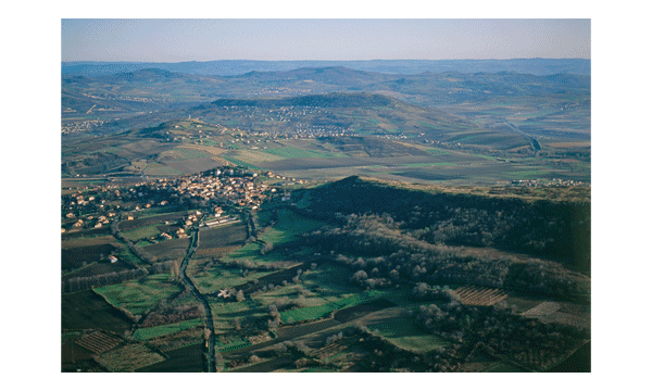
The Montagne de la Serre
Age :
– 3 million years
What is it ?
The Montagne de la Serre lava flow is 10 km long, and is bounded to the sides by the Veyre and Auzon valleys, and at the far end by the village of le Crest. It dominates the southern part of the Limagne Plain, and is flanked by other examples of inverted relief, such as the Plateau de Gergovie.
The lava flow originated from the Puy de la Vigeral, a volcano situated at 1,000 m, on the Plateau des Dômes, where it overshadows Lake Cassière.
This is an example of inverted relief, testifying to a major phenomenon linked to continental break-up: that of extensive uplift. As the ground surface rises, the degree of erosion increases, particularly where softer sediments are concerned. More resistant rocks, such as lava flows and continental basement (Plateau des Dômes), are less affected, and thus create higher ground. Areas of more resistant rock such as Gergovie and the Montagne de la Serre therefore stand out as raised areas known as inverted relief.
The Montagne de la Serre is particularly interesting as it straddles both the Plateau des Dômes (ancient continental basement) and Limagne Plain sediments (downthrown graben). The fact that it is not cut in two by the Limagne Fault shows that it formed after subsidence had taken place, when the Limagne Plain had been infilled to the same height as the plateau. The uplift and erosion thus occurred as a second phase. The Montagne de la Serre illustrates the chronology of the entire sequence, from faulting, subsidence and sedimentary infill, through to volcanic activity, uplift and erosion.
Formation of the Montagne de la Serre
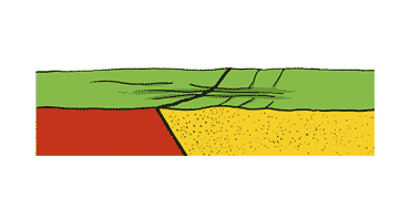 Stage 1
Around 5 My, before emplacement of the Montagne de la Serre lava, the sedimentary phase came to an end and the sedimentary infill of the graben reached the same level as the adjacent plateau.
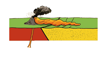 Stage 2
Around 4 – 3 My an eruption resulted in a lava flow which spread across the plateau before being channelled into a valley in the sediments.
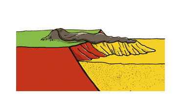
This flow lay partly on the Plateau des Dômes (shown in red) and partly on the sediments (shown in yellow).
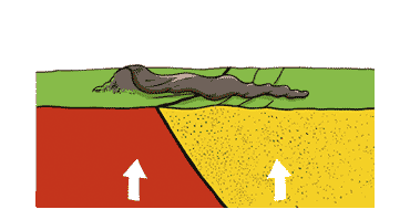
Stage 3
Towards 3 – 1 My the basement and sediments were uplifted together, triggering intense erosion.
Stage 4
Towards 4 – Erosion led to the preferential removal of the softer sediments surrounding the flow. The more resistant lava formed a protective layer which preserved both the lava and the sediments lying directly underneath it.
The result is an upstanding area, forming what is now known as the Montagne de la Serre. The evolution from valley-infill to upstanding plateau results in inverted relief.
Did you know that 30 Million years ago the Limagne Plain was a huge lake? This is shown by sedimentary rocks in the plain, for example those composing the hill at Chadrat, where the Montagne de la Serre meets the Limagne Plain, where there are numerous fossil fish and marine structures (stromatolites). If you look closely, you can see them in the stones used to construct the houses in the village of Chadrat.
